It turned out to be a terrible place to sleep. Despite removing the big stone, there was still a huge lump in the middle of my back making it difficult to get comfortable, and with the overnight temperatures dropping into the low twenties or below, I felt a little bit chilly all night as well (though never shivering cold–just too cold to sleep). On top of that, it was a Saturday morning on a popular trail for day hikes, with the first tourists bellowing their baritone conversations down the trail beginning at 4:50am leading up to a continuous stream of boisterous chatter on my front porch, so to speak, by 6am.
I decided I could do something about exactly one of those problems, and started my morning by boiling several liters of water and putting it back in my water bag, to be promptly stuffed under my jacket. Thus elevated to a comfortable temperature, I slowly went about getting myself ready for the day. Ted was on roughly the same page. We finished packing up about the same time–around 6:30–and joined the throngs thronging the high peaks.
About the time we came up onto the ridge that rose up to Grays’ north face, I was getting fed up with slipping and sliding on the compacted snow. I ordered a stop to put on my microspikes (for the first time ever!) and Ted took the opportunity to get out his poles. He had no traction devices with him. This arrangement made, we started making great time, passing a number of people on the way up.
Once on the face, we left the main trail at a switchback, joining the Torreys connector trail. This was a much less frequented trail, only a few footprints trampling down the snow. And those footprints led us astray. We had to climb straight up the slope to rejoin the actual trail later. We met a couple of Indian guys coming down. They had literally gotten cold feet before even making the saddle due to low-top shoes leaking snow and no gaiters. Basically, similar shoes to what Ted was wearing. In short, they were wimps.
We dropped our packs when we reached the trail junction with the ridge and stuffed some snacks in our pockets to do the climb up to Torreys unburdened. Though there was a hellacious cold wind at the junction and in the saddle between peaks, halfway up Torreys the wind disappeared. Even without pack weight, it was a pretty slow climb just with how easy it was to get winded at that elevation.
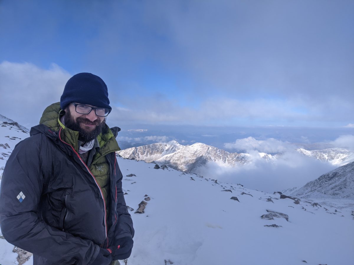
The whole morning the peaks had been shrouded in clouds, only occasionally and briefly clearing up only to be consumed by another cloud moments later. So it was when we both summitted our first fourteener. But it wasn’t windy or particularly cold, so we sat down and waited. Within 15 minutes, the cloud bank disappeared and we received several precious minutes of unobstructed panoramic views–with the exception of the cloud that refused to release Grays Peak from its embrace.
Our days already made, we retraced our steps back down to our packs for a water break. A lovely girl handed me a delicious piece of chicken and cube of cheese from her morning meal here. I’ll count it as magic!
With the wind having died down even here, I removed and stowed my jacket for the next climb. We shouldered our packs and lugged them up the much snowier climb to the summit of Grays Peak. And just before we reached it, the mountain removed its own foggy mantle, granting yet another gorgeous panorama–except, of course, for the summit of Torreys, which had regained a cloud. I was a bit disappointed since the other visitors on the summit with us had brought beers to celebrate. Oh well.
Ted and I started down the south ridge of the peak as soon as we had finished our own celebrations. I led the way, taking advantage of my traction to create tracks in the snow. We stopped a few hundred feet down to look at the views and, in my case, to celebrate finally being far enough from the tourists to make some yellow snow without being unmannerly.
It was at this point Ted informed me that this was the wrong ridge. We wanted the northeast ridge. We climbed back up the way we had come and then cut across near the top to the much steeper, rockier descent onto the knife edge ridge connecting Grays to Mt. Edwards and beyond.
This infamous stretch of trail, only a couple of miles to the summit, is a lot of work. Not only is it a lot of picking your way over and around rock piles and scrambling up the steep ridge, it was also covered with a fairly fresh layer of snow in places. But not enough places to warrant the spikes, which I stopped at the bottom of the initial descent to remove.
The sun finally came out during this interminable stretch as the clouds got higher and smaller. At some points on the climb, I removed my jacket, removed my snow pants, swapped my balaclava for my sombrero, and put sunscreen on my legs.
The trail got vastly easier after attaining the summit of Edwards, where we stopped for lunch. (I had Palak Paneer wrapped in Spinach and Herb Tortillas thanks to Slowcahontas.) No longer a sequence of steep rock scrambles or loose scree fields, the ridge spread out a bit into somewhat wider snowy rollers. Although I had led on the majority of the knife edge, we started swapping lead frequently as we joyfully bounded through the snow over a series of smaller peaks with clear trails and footprints to follow. We came upon another hiker for the first time since leaving Grays here, climbing up to Edwards from the much easier section of trail we were heading into.
It had taken us about 3 hours to do the 1.4 miles from Grays to Edwards, but it now took us only an hour or so to do the 1.1 miles down to the pass. A pass, by the way, with a truck parked in it as we approached. We were surprised to a vehicle way up on the 13000 foot ridge with us, but we would get used to that eventually. In the meantime, we were happy to see the road in front of it, which we knew led to water and good camping. It was still early afternoon, but we had put in enough work for the day. We needed some celebration.
At the bottom of the slope, we crossed the Peru Creek on a small bridge and joined Peru Creek Road for an easy 3 mile jaunt further into the valley. It was a relatively heavily trafficked road and a popular area. In fact, when we reached the turnoff for the Chihuahua Gulch Trailhead, we saw the biggest crowd of people I’ve seen on the trail this year. Even though the lot was on public land and could only be accessed by fording the creek (or walking over it on a fallen of like us), there appeared to be a wedding ceremony wrapping up. Parked on the road all around the lot were a couple of dozen Jeeps (and a couple of Subarus sticking out like sore thumbs). The only wedding I’ve ever seen that could only be reached by four-wheel drive.
The CDT skirted this madness and followed a steep road winding back up the hill toward the ridge. An hour or so later, we reached a nice stream crossing the trail next to a perfect little campsite. There was a cold wind falling down from the ridge, but there was also an enormous fire ring. We set up tents, and while I added several cold weather layers, Ted started gathering firewood for our celebration of doing our first two fourteeners and one of the trail’s most infamous sections with sunshine to spare. We got a roaring fire going and hung out next to it until 8:30. Socks were dried, gloves were warmed, supper was eaten.
It was still quite a chilly night in the tent once we put out the fire, but it was a good day overall, even if the mileage doesn’t show it.
Trail miles: 11.3 (but actually a wee bit more than that!)
Distance to Frisco: 49. 7 miles


