My plan to sleep out in the open with the breezes worked perfectly. I woke just before 6:30 with the sunrise. No condensation in the tent at all. I punctured a blister on my pinky toe and retaped it, then came out to another clear sunny morning. I tore the outer pull off my tent’s rainfly zipper when I zipped it to pack it up. In fine spirits, I rolled out of camp at 7:45 and promptly lost the trail on the brushy hill crisscrossed by cow tracks even though I could see exactly where I was trying to get to.
From the ridge, the village of Canjilon was coalition visible below, and cows and elk were bellowing over the hill. The trail wound through a grassy field near a road, which meant a lot more opportunities to trip on tufts of grass than if I just stayed on the road. I briefly paused at a gate where there was Verizon service to look up Ghost Ranch breakfast time. A little past that, the trail came through a stand of aspens where all the cows liked to hang out, so I sat in the shade and had a snack while watching them. One cow studied me for a moment, then walked right past me on her way to, I suppose, a salt lick. Another climbed under a dead tree and started breaking branches for who knows what reason. Most huddled in the shade and watched me because, with the breezes mostly having died off, it was a bright hot day.
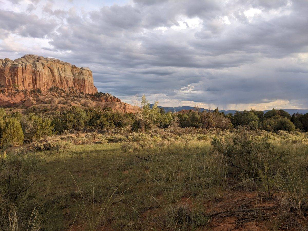
I continued across the ridge of cow pasture, into a proper forest, down another brushy hill with an easy-to-lose trail, across yet more cow pasture on a rapidly disappearing road marked as the trail only by markers attached to occasional aspen trunks (which are always in shade and therefore impossible to see at the distances between them) until I reached the turn-off for the ghost ranch alternate. Just down the road was the Rancherilla Spring, my water source for the day.
I stopped here more than an hour. I snacked, drank, did some glove stitching, cleaned up a bit, dunked my shirt shadowy against the heat, and by the time I was ready to go, I could hear thunder in the distance. Which was odd because I could see no storm clouds on my side of the hill. Just puffy white cotton balls and thin wisps. It still looked like a beautiful day.
The road continued in much more readable fashion through more cow pasture, then, with a turn onto another road, headed out to the edge of the mesa. It seemed like perhaps the interesting part of the trail was behind by now, and there wouldn’t be any elk hanging about these parts. By lunch, which I took on a roadside rock, larger darker clouds came rolling in. They were all around, but it took ten way too long to have the good grace to pass in front of the sun and cool me off. Thunder boomed in the distance again.
A short jaunt down the road, I left it for a less-used road, and about that time, the drops started falling. Big ones. By the time I had my Packa on, they were coming fast Enough to require the full protection of the coat. It looked like a single small cloud that would pass, but it put out some spray, complete with a few shocks of lightning.
Very soon after that, a single track left that road right where it petered out entirely. I missed it, of course, but it was easy enough to cut across the hill to it. And about this time, some fifteen minutes after it started, the rain tapered off. I knew there were more clouds on its tail though.
The trail ran along the edge of the mesa for a moment past a few nice views before turning steeply downhill. I followed a series of small cairns down to a well-maintained leveled dirt road that started down the Arroyo del Yeso (Gypsum Creek). No sooner had I turned down the road than the rain started again, and right back on went the coat.
This time it was a big cloud bringing some persistent, thick rain. Enough to find the leaks in the Packa’s seams. Enough to turn that dirt road into a slippery slope. I was mostly able to avoid the muddiest parts in the middle and find rocks or pebbles near the edge that provided more traction.
A left turn at the junction took me out onto another mesa where the biome promised to change. I came past the Yeso Tank, which was somehow empty despite all this rain, followed a parallel grassy track to avoid some of the deepest parts of the mud road, carefully stepped across the runoff streaming across the road and… saw an umbrella floating down the road towards me.
Okay, it was more like the umbrella was walking. Or was hovering above the hiker who was walking. She was done up in her rain gear head to toe, rain pants splashed with mud, but the umbrella was attached to get pack in such a way to cover it and her head while leaving her hands free. Her name was Anne Marie, and she was on a section hike from Grants to Breckenridge. She said she was getting up early, hiking out at dawn, and doing 15 miles a day, sometimes stopping at 4 and hunkering down when the rains started.
Given it was nearly 4 already, she had spent the previous night at Ghost Ranch only 6 miles away, and she was walking in the rain (and occasionally falling in mud puddles), she clearly wasn’t following that plan today. I think she must have stuck around the ranch long enough to get the lunch her stay included too.
The rain stopped at the same moment we ended our conversation, so on I went toward the edge of the mesa. The road ahead was significantly less muddy than before, and the change in biome began. There were still tall pines about, but there were more and more creosote bushes. I took a snack and drink break on a log, and I actually put up my Packa because it looked like there were no more storm clouds on the way. I wanted to sit a bit longer, but the flies had gathered and were starting to drive me crazy.
Then the road ended and a steep, rocky trail down to the next lower mesa level began. Now I was starting to see some of those stratified rocks you associate with the southwest. As the trail went over the muddy creek of rain drainage and around the base of the cliffs I had just descended, there were no more pines, only sagebrush, creosote, mesquite, prickly pear, and… cholla! In bloom! Cholla topped with perfect little flowers in pink and purple. How pretty!
And then my hand accidentally brushed up against a short one hiding among the sagebrush and my hand came away with several spines in it, including one fat one sunk deep like a porcupine quill. The grip and pulling force it took to yank and pop it out made me think it must have had a subtle barb on the end. The cholla grew thicker and thicker along the trail until getting by them was akin to a more painful version of getting to your seat in the middle of the row at a theater. How evil!
Finally I came to the mini ravine for the little side stream that cataracted down into the main arroyo. It was a steep, rocky trail down into the bottom of the arroyo marked by little pink flags. Right away, I rolled my ankle on a fist-sized rock in the trail. It was the hardest roll an ankle has taken this trip. Rocks like that are exactly the reason I bought high-ankled shoes. Without them, a turn like that could have been a serious injury, days of limping. But as it was, the ankle took weight without pain just a half-minute later.
At the bottom of the ravine, the trail followed the creek. Like a muddy track right beside it, back and forth across it. There was no way to avoid the mud sloshing over my shoes, my shoes sliding dangerously over the surface of the mud nearly spilling me on several occasions were it not for trekking poles, or mud trying its best to suck the shoes right off my feet. But I could avoid stepping directly into the murky water rushing down the canyon, so my feet pretty much stayed dry.
On the bright side, I was yet again in a different and unique biome, the “desert dry wash” biome which is unique to arroyos in the American southwest. One unique thing found here is translucent green salamanders, and I found two of them.
This muddy creek crisscross trying to follow the little pink and orange flags lasted for another half-mile until I finally completed my last rock-hop and came out of the neck of the box canyon. I think this little bit of trail, from the moment I began descending from the Mesa del Yeso to the mouth of the arroyo would be classified just slightly above “dynamic”. It certainly took longer than expected.
Although I passed a sign just before the canyon opened up that said “Leaving Ghost Ranch Entering National Forest,” it was a lie. I was still in the national forest, and the road I soon came to was a national forest road. Ghost Ranch had signs posted along the road, there were memorial plaques on rocks across from a nice little pond, a wooden tombstone with a Star of David on it and a whole wall of memorial plaques at the base of a cliff. It felt like stuff Ghost Ranch had put in, but nonetheless, I was well into national forest territory.
I left the road and headed up into an amphitheater-shaped cut into the cliff, looking for a place to camp, knowing Ghost Ranch was only a mile downhill. I came into the area around 7:30 or sooner, but it was 7:45 before I decided on a spot. the way the rock walls curved around and the trees grew in gave me a lot of privacy, but I wasn’t very happy with the soft red dirt. Unfortunately, it was the only surface available. I stomped it down with my boots and got some rocks to hold my stakes down.
I was moving pretty slow, famished from hunger, but I wanted to get my tent up before I did anything else because I was surrounded by storm clouds hanging oppressively over the valley, not really going anywhere. Some lightning and thunder in the distance. None were overhead or over the mesa, but I wanted to be ready with some cover to dive into if things changed.
Nothing changed. The absolute muggy stillness didn’t take the clouds away nor move them toward me. I cooked, made my bed, ate, stripped off my muddy shoes, and crawled inside the tent. I had set it up the other way around so as to come in through the side of the tent flap I hadn’t been struggling against for weeks. It had its own difficulties, but it didn’t require twenty minutes of fight to close.
Even as late as ten o’clock, I still hadn’t pulled out my sleeping bag. It was hot in the valley and even hotter inside the tent. But at least I was finally free of all the flies and mosquitos that had been pestering me all evening. The birds outside were still twittering away in the heat as I called it a night. No more days of rain.
Trail miles: 18.6
Distance to Hwy 84 at Ghost Ranch: 2.9 miles


who is this sign for? 

that’s not a planter. the tree just grew inside an abandoned wheel 


Annemarie 
flowers! 


those aren’t puddles. that’s the arroyo flowing by. 
cholla in bloom! 


muddy cataracts 

the arroyo is probably almost a foot deep here 


the arroyo leaves the box canyon 
Camposanto 


an oasis 
