Another cold morning meant sleeping in until 7. It wasn’t cold except when a chill wind came whipping through the cabin from the opposite direction it had the night before. That kind of unpredictability was why I put my tent in the middle of the room. Wind could blow the rain in but none of it could reach my tent. Hence, everything was dry that could be dry. Which is to say, everything was dry except the wet socks I donned and inserted into wet boots.
At 8:30, I left the cabins and walked over the bridge to the campground. I talked to a nobo on the way up to the trailhead, the first Black CDT hiker I’ve seen out here. They are rare, but they exist! There were a number of other backpackers just leaving, some wanting to talk to me, some that I would see later in the day.
My first stop in the campground was the administrative building, namely the trash cans in front of it. One of the guys working there really wanted me to know that “we are the ones who have to pack that out” before he let me add my trash to the bin. Of course, my trash was small and weighed less than a pound, and his “packing out” meant driving out in the back of a truck, so it really was easier for him than me.
Next stop, carry my water bag over to one of the many spigots throughout the campground. Since it was easy and would save me time later, I filled it right to the top. Then, I hiked right back out the way I came in.
As soon as I crossed the bridge again, I met another hiker out to do the Wyoming section of the CDT southbound. We both had the same plan for the day: get to Peak Lake on the Knapsack Col alternate and see whether it would be passable given the amount of snow there was up there after all those storms. We had high hopes because it was shaping up to be a beautiful warm clear day (aside from that cold wind) and would indeed be exactly that. We never got around to introducing ourselves in all the eagerness to hike, even when we met again and again.
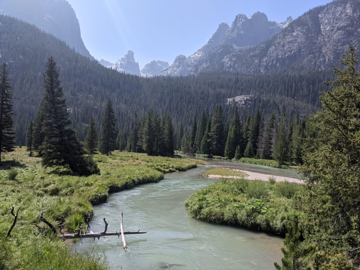
I passed hiker after hiker coming around the east side of the lower Green River Lake. It was a surprisingly popular trail. Most were headed north, some were just sitting in chairs with an indeterminate direction, some were fly fishing the river (but from the bank–that glacial melt was far too cold to stand in), but I passed other pair of old guys aimed for the same part of the mountains as me. One of them wanted to chat about moose the second time he caught me. Based on his pace, they wouldn’t be getting anywhere near as far as I planned to that day.
Once I got to the last bridge over the Green River, I didn’t see any more going my way. I stopped for lunch in a sunny clearing (it was still cool in the shade just before the trail started its big climb into the mountains. While seated there, I saw three northbounders coming down, but no one going up. I also changed into my dry, thick socks because my boots were dry and the damp socks were making my feet hurt.
The climb itself wasn’t too bad. It was mostly really gentle switchbacks and had been pretty well cleared of blowdowns, except for one at exactly head height ready to bonk me. I was able to climb at basically the same speed I go over level ground. The only major obstacle was the Trail Creek crossing. Normally, it’s an easy rock hop to cross dry this time of year, but after all that rain and snow, it was raging. I went a long way upstream but could find no easy rock hop routes. Eventually, I crossed on a pine tree downstream from the trail, not an easy feat. But I kept that nice pair of socks dry.
I could keep that steady climbing pace pretty well until the turnoff for Vista Pass, a much steeper trail with a lot more blowdowns. It had been a few hours since lunch at that point and I was starting to drag a bit. So once I gained the more level ground near the top of the pass, I pulled over to a sunny rock near a shallow pond to make supper. I had just started boiling the water when the old southbounder guy from the morning came over to join me briefly. Then he hiked on ahead to do the last three miles to the lake. It was nearly an hour before I finished up and followed him out.
There were more blowdowns and water and mud in the trail for the first mile, though, riding high on the dinner energy, I didn’t let those things slow me at all. Soon I was crossing a scree field, and someone had sort of arranged the rocks into a kind of path. Then I crossed the creek and ran into a wall of boulders. It was a matter of finding my own way from cairn to cairn for this little bit, a real Abol Slide Trail (at Katahdin) moment.
But once I got high enough above the scree, something more like a trail reemerged, and I picked up the pace again. Near the top, the trail turned into a streambed, and I hopped from side to side, staying on the high rocks to keep my socks dry.
There was even more water and mud in the trail as I took a hard turn left and came over Cube Rock Pass, and it was a stream again all the way down the other side to the lake. I started avoiding the trail and finding other ways down. My socks came out slightly damp but largely unscathed. And I got to see my first pika of the year. Finally, some proper mountains!
Since I would be camping down there, I hoped the bowl of the lake would have some good wind protection, or that I could find a protected spot for my tent. Hope for the latter was dashed when I saw just how many tents there were already at the lake. The place was mobbed. A difficult side trail to the foot of an even more difficult climb at an elevation of 10,500 feet, and everyone and their brother had come out.
Pickings were slim for campsites that were on only slightly damp ground, so holding out for wind protection seemed a lost cause. I found the chatty old guy who was on the same plan as me, and saw a little shelf to stick my tent just around the corner from him. It was on the wrong side of the rocks to be out of the wind, but I didn’t see anything better around, and it was getting late.
With the tips now broken off both trekking poles, it took some time to get set up in a wind-resistant fashion. My only blessing was that the forecast I downloaded said that even with the windchill, it would only get down to 36 that night.
I was glad to have the first nice day and night in a while be right when I was planning to do this section. What lay ahead didn’t really even deserve to be called “trail.” If you remember my trail classification, it would fall somewhere near the bottom end of that. A 2000 foot choose-your-own-path up a scree field over the course of just 2.5 miles. And then something similar down the other side. It wasn’t possible at all without good weather, much less worth the effort. But on a good day, the views should be incredible.
Trail miles: 17.8
Distance to Pinedale: 20.8 miles


