I actually started packing at the 4am alarm for once. I didn’t have the excuse of getting in late this time, so I packed up and got out around a quarter after five. One side of my tent had condensation, so that cost me a couple of minutes drying it, but everything else went smoothly.
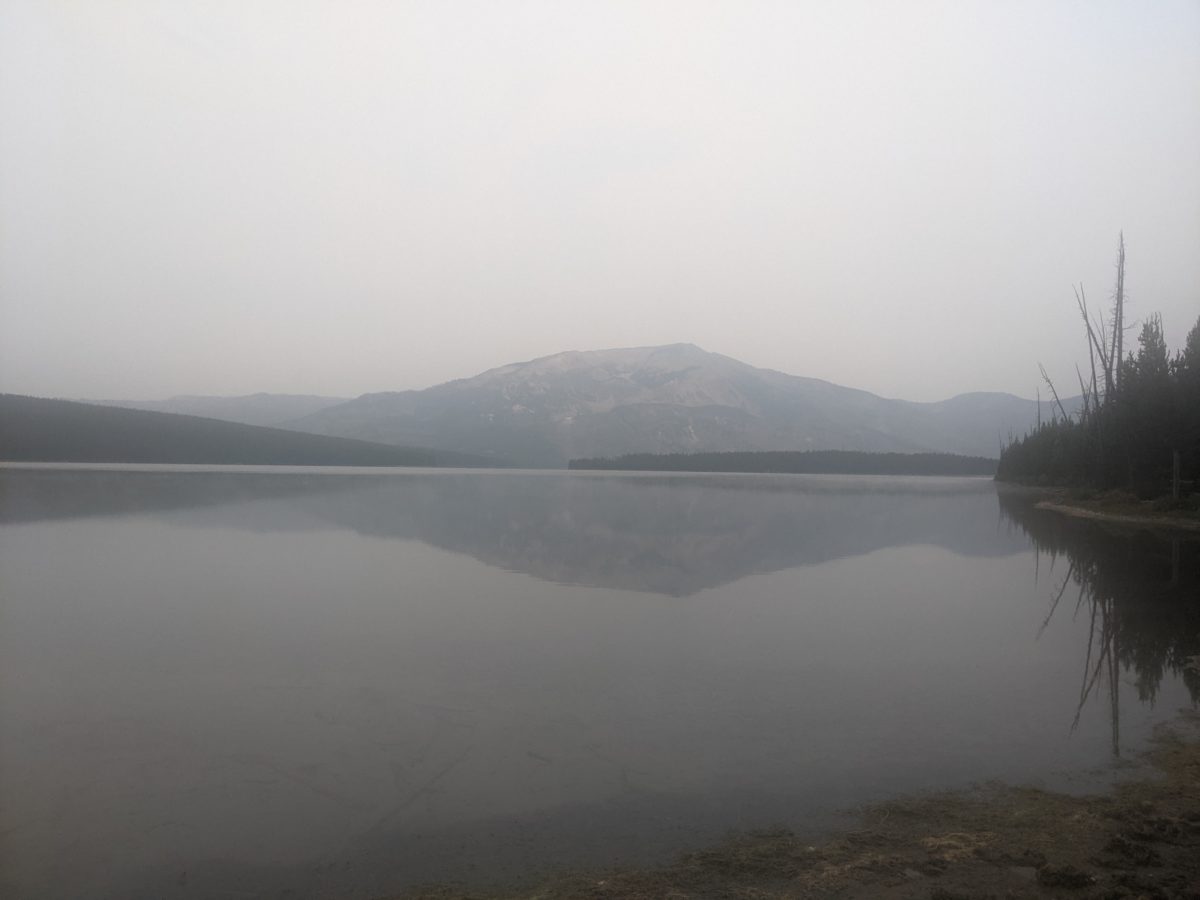
And the first couple of miles of trail were really easy. Both objectively easy and my-legs-are-fresh-and-ready-to-go easy. I arrived at the turnoff for campsite 8J6 (East Shore) about an hour later, my headlamp long since turned off. I wanted to see the beautiful view of the lake reflecting Mt. Sheridan on the opposite end and all the morning motion and coffee wanted me to find the toilet.
I paused on the shore to say hi to a rapidly evacuating porcupine and take some lake pics. I paused in the campsite to say hi to the campers who had spent the night there and were just leaving. I paused to say hi to the toilet even though I know toilets don’t have ears. Then, instead of going back out the way I came in, I followed a clear and frequented but unmarked back trail out of the campsite.
It led me to the bank of Heart River where it was slowly draining the lake. If I continued along it, it would connect me back to the CDT at the Heart River campsite, where I would need to remove my shoes to ford the river. So I took a little time to find a way to cross the river here where it was shallow with easy rock hops for 90% of its width. I found a dead tree I could break a section off of to build a ramp across the last little deep section on the far side and tossed in some large rocks next to it for stability and backup. Then, in an anticlimactic instant, I was on the other side with dry shoes.
But I was way upstream of the trail and separating me from it was a very steep bank that ran down to the water’s edge. I may have lost twenty minutes of time climbing that bank and working my way through a thick stand of very young pines at the top until I reached the trail. But I got through it with only one minor scrape on my knee and a ton of dead pine needles all over my hat (which had protected my face from the trees) and every crevice of my pack. I stopped for my first snack break of the day as soon as I reached the trail, and picked off all the pine needles while I was there.
The ironic thing was that I had to cross the same river again just two miles further south, and there was no way to do it without getting my feet wet there. (You know I gave it a shot though!)
This put me into the main Snake River canyon leading up to its highest headwaters. I knew I would have to ford the river in 8.3 miles, and which was a distance I expected to be able to cover by lunch time. So I turned the expectation into a promise and decided not to eat lunch until I reached the next ford. Honestly, I was looking forward to it, for reasons which shall be clear.
But the trail didn’t want to make it easy for me. Sure, because I was following the Snake River upstream, I had to be going uphill the whole way, but the trail was cut into a hillside set back from the river, and kept going steeply up, steeply down, alternating between climbing and descending (but always more of the former).
By 11, I had reached Sickle Creek, a good source of water, but not shade. I sat in the shadiest half-shadowed spot I could find and started some water filtering while I filled up on snacks enough to get me to lunch.
Right after that was the longest steepest climb of the section.
It took another 2.5 hours to reach the crossing only 4.1 miles ahead because the trail just stayed as steep as it could at every moment the whole way. I was never so happy to reach a river ford when the end of the 1 o’clock hour arrived.
I was starving from the long strenuous stretch without food, so my priority was to find a shady spot to eat lunch. I found a nice sturdy log lying under some shade trees between a small meadow and the river and set up shop. I grabbed some water and started it filtering. I finished lunch, changed into my sockwas, emptied my pockets, and waded into the river.
The hole next to the crossing was deep enough that I couldn’t touch the bottom with my head above water. It was quite cold, but slightly warmer on the side with new water moving into it. When I finished up and climbed out, I noticed much more sharply that the wind had picked up. My wet shirt wasn’t letting me hold onto my heat. I was shivering within the minute. Thinking it would be awfully embarrassing to die of hypothermia on an 80+ degree afternoon, I took off my shirt and hung it over a tree to warm up. It was a bit better without it, but it took a solid minute before my nipples softened enough that it didn’t hurt to touch them.
Anyway, I got back to my stuff packed up, hung my boots from my neck and waded out into the river again. On a log up the hill on the opposite side, I finally got to put my boots back on.
The next bit of trail was much easier than what I had been doing for the last few hours, so I moved more quickly. And I warmed up so quickly I was missing the ice cold shirt on a heartbeat. There were some nobos just coming into the park here, hoping to do those 9 miles to Snake River in the next 4 hours. I’m sure they had no trouble with it, being hikers who aren’t me.
In a bit over an hour, I was rock-hopping across the Snake again and keeping my feet dry. The trail followed the boundary of the park from this point to the ranger cabin that sits opposite where the CDT enters the park. Just shy of said cabin, I stopped on a rock to eat dinner. Sure, it had only been a few hours since lunch, but it had been a very late lunch, and it was actually already dinner time.
And then I left Yellowstone for good. Although it turned out to be a much more ceremonious exit than entrance. Does anyone know why the Forest Service signs are so much nicer than the Park Service signs? The big wooden Teton Wilderness sign both dwarfed and outclassed the Yellowstone Boundary sign.
Leaving the park meant leaving the relative flatness of the terrain there. Not immediately, no. I got a nice, easy 2.5 mile stretch still following the Snake upstream at just enough distance to stay out of its bogs. But then I came to my final Snake crossing, at this point, a mere three miles or so from its source, nothing more than a creek maybe ten feet wide and an easy rock hop. On the other side of the river began a steep half-mile climb the likes of which I hadn’t tackled in nigh on a week. At the end of an already grueling day, it felt a bit like torture. But I told myself I would stop at 7:30 regardless of where I was.
Where I was at just before 7:30 was a perfect little flat site in a lovely flat section of forest on top of the hill I just climbed. I liked the look of it so much I couldn’t pass it up. I managed to get set up and in bed by 8 and turned off by 9.
Trail miles: 20.8
Distance to Dubois: 44.1 miles


Mt. Sheridan over Heart Lake 


Unavoidable feet wet crossing 
Snake River snaking 


