The plan to get up earlier worked perfectly. In fact, I was awake before my 4am alarm even went off, and I was back on the trail by 5:20.
And five minutes later, I resumed my climb. 3.6 miles to climb 1422 feet to the ridgeline to Caribou Peak. Rather than watching the sun rise, the sun rose behind a mountain and then I rose until I could see it.
All along here, I had cell service, so when I stopped just before the ridge for my morning break, I decided to go to work getting some more pictures and videos and posts uploaded. After an hour of this, the cell service suddenly dropped, so I relocated. Then I relocated again and put in another hour sitting on the ridge and getting 3 posts ready to go while dealing with a lot of storage management issues. It cost me a solid third of my phone’s battery. And it got hot out while I was sitting up there.
After the third post, I said enough is enough; I need the rest of my battery life for hiking. And so I hiked on.
The only other hiker I saw all day was a northbounder who arrived at the “lake” (read: evaporating puddle full of red bugs and the only water source on trail for the next 12.5 miles) in the valley under Caribou Peak at the range same time as me but headed north. He told me he only saw two blowdowns in the trail in the last ten miles (that I was about to hike). So when I left to climb yet another annoyingly steep hill out onto the ridge (700 feet in about a mile), I started counting. I counted at least four in the next two miles and then none after that. The forest service does a great job.
Also, while I was at the lake, I discovered that the other half of my hip belt had become completely unbound from my pack, so that the whole thing was riding up and allowing the pack to sink until all its weight was on my shoulders and tailbone. After a mile or two of trying to hike with it in this failed state, I had an idea. I stopped and rearranged some of the straps on the bottom of the pack to loop around the framework of the belt and prevent it from riding up. I wouldn’t say it was completely comfortable after that, but it was at least wearable without immense pain.
If I had to describe the next 10 miles, I would say “Appalachian Trail-like.” In particular, it wanted to keep me as close to the center of the ridgeline as it could, no matter how much it meant I had to pointlessly go up and down hills. And it only employed switchbacks where it would actually be impossible to go straight up or down the slope…and it set a high bar for impossible.
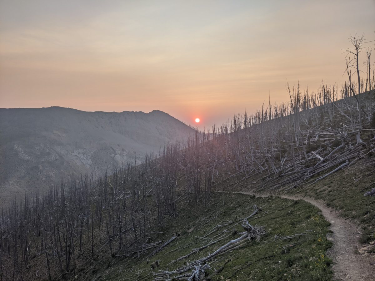
On the bright side, most of the hilltops and ridgeline were exposed, which meant I had excellent panoramic views of the smoky haze from the wildfires all day. Which is to say, it reminded me a lot of my day on Franconia Ridge in 2013, but with fog swapped for smoke.
By lunch I had barely hiked eight miles if that, but I had come over the highest point of the day. The rest of the day was more down than up…for what that was worth, as there was still plenty of up. And since I knew there was a lot of heat, swarms of flies, and seemingly limitless legwork ahead and I was already fading, I took a Stacker-2 B-12 10000%. And it helped at first.
I took an afternoon break in the shade of a tree down from the last short climb before Lewis and Clark Pass (I guess this is where they crossed the Divide?). From there, I could face down my last foe of the day, the final boss: Green Mountain.
And I did procrastinate just a wee bit on heading off to tackle it. I could tell by looking at it and its elevation profile on Guthook that it was going to be a monster. But I needed to go 3.9 miles over the very peak of that mountain to get to a spring on its south face where I could stop for dinner.
So I packed up my stuff, psyched myself up, and… delayed. I was worried about my battery power, and I was thinking about heading into Lincoln the next day just for a couple of hours to recharge my devices. So I wanted to look at the restaurant options for a place to sit while that happened. And then I noticed a waypoint for something people had been mentioning: the High Divide Gear Store was right next to the trail just a day’s hike further on. So I turned off airplane mode; I had service. I called them up and asked if they had electricity. Sure enough, I could avoid the tricky hitches both into and out of Lincoln with a stop there instead.
At the same time, I also received a text that Sam in Leadore, the man I had left a package with and got the cell number of in order to get a ride into Leadore when I got there, had died. No word on the cause or how this will effect my plans as yet. But I do feel lucky I got to meet the man before the end.
Okay, enough delay. I hiked down to face my foe. The 1.8 mile descent to Lewis and Clark Pass was rocky and a bit painful on my feet, but it went by in a heartbeat. The climb up Green Mountain, on the other hand, took a solid hour. It was about 1000 feet of ascent in about 1.2 miles. That’s Mahoosuc Arm steep. I tried to capture it in the pictures, but there were sections that were 45 degrees or steeper. It should have had stairs cut into it. In fact, the only reason it could be climbed at all was a thick bed of gravel and, further up, ankle roller sized rocks. Previous hikers steps had shaped the rockslide into a series of stair-like indentations. And this steep section started halfway up an already steep climb. It continued being nearly as steep all the way up, always in direct sunlight, but at least there was sometimes a breeze.
Finally, after taking an entire hour to go one mile, I could look around from the peak and see all of… nothing. The looming shapes of nearby ridges emerging from the haze.
Fortunately, the spring was now only 0.6 miles away, all downhill! I flew down a couple of switchbacks (hey, they should do more of those!) and arrived at the spring within two hours of leaving my last break, thereby maintaining my 2mph average for the section. I threw out my stuff and myself onto a nice trampled down spot under a tree and got busy on dinner. While that was cooking, I drank all the rest of the water I was carrying and filtered some more from the spring. I go through at least 6 liters a day lately with all this heat.
It was already 7 by the time I finished dinner and got packed up, but there were no good campsites in sight. If my new schedule was to work, I needed to get to bed ASAP. Fortunately, there was a blocked-off road meeting the trail just a little ways down the hill. It was level and campable. I got set up and inside by a bit after eight and was ready to sleep by a bit after 9.
Trail miles: 17.6
Distance to MacDonald Pass: 75.0 miles


Rising to see the sun 


“Lake” 


Green Mountain summit 
Green Mountain Spring