I’ve come up with a rating system for trails based on my pace over them. It goes like this:
- 4+ miles per hour: Literally a walk in the park. (Example: Hat Rim on the PCT)
- 3-4 miles per hour: Easy Trail (Example: any of a number of mostly downhill road walks on the CDT)
- 2.5-3 miles per hour: Moderate Trail (Example: Most compacted clear footpaths that aren’t uphill)
- 2-2.5 miles per hour: Challenging Trail (Example: The harder bits of the PCT, uphill sections graded for horse)
- 1.5-2 miles per hour: Strenuous Trail (Example: Climbing Stone Mountain)
- 1-1.5 miles per hour: Bullshit Trail, and at the lower end of this range, Complete and Utter Bullshit Trail (Example: The 45 degree climbs strewn with rocks and fallen trees I’ve been dealing with the past two days)
- Less than 1 mile per hour: What Trail? I Don’t Think There Was A Trail… (Example: The Mt. Hood Fiasco)
On this day, I was fortunate enough to be back on mainly moderate trail.
I left camp before sunrise this time, a bit worried about the water situation. I had maybe 20 oz left and put it all in my breakfast smoothie. I had 3.5 miles to go to the parking area, and from there it was a mile down to Dutchman Spring on the road. And the first bit of trail was a couple more of those ridiculous climbs I’ve been dealing with that easily earn the Bullshit rating. But on my Fresh Morning Legs (FML), I knocked them out fairly quickly.
At the top of the second and larger hill, blessed be, there was an actual footpath! And soon that became a full-on road! Downhill and basically free for 1.5 miles. It was here I spotted a group of elk below and could hear their calves squeaking loudly when they left.
Then it was another steep climb next to a barbed wire fence (of course), but at least there was somewhat of a track up it, and it was short if not mercifully so.
Anyway, I made it to the parking lot by 8, and yet another miracle occurred. There was a row of four 5 gallon boxes of water next to the fence. I made a morning drink to go with my morning snack and filled up everything and more to go. No mile round trip to the spring required! At least an hour of time savings! A great way to kick off a supravigintal day!
(I should mention that the title of this post refers to the fact that this parking lot is the north end of the Gila River Alternate. The next few miles from here are hiked by every CDT thru-hiker, though the confluence doesn’t last long.)
The sun was out and the trail was exposed ridges (more burned forest) for the next few miles. A couple of short climbs but nothing too bad. I took an early first lunch to celebrate my advanced schedule for the day in a flat area with trees dotting it irregularly. I picked one short enough that its shadow was unlikely to leave me and ate and laid in the shade, psyching myself up for the day’s first big climb coming up in less than two miles. I made my weird vitamin C drink to keep me pumped.
Approaching that climb, the clouds got a little thicker. One actually sprinkled on me for about a minute at noon. I went across the long flat section approaching the climb as quickly as possible begging a cloud to give me shade once it started. And the clouds obliged. Some of the worst parts of the climb were in the shade. Which isn’t to say it was anywhere near as difficult as the previous day’s climbs. There was an actual track and switchbacks for goodness sake! But carrying a pack full of water up 700 feet in less than a mile is never going to be easy.
So once at the top, I stopped at the first nice sitting log I could find and cooked one of my extra dinners for second lunch. I figured I’d restore all the energy lost on the climb. While it was cooking, I had to resist curling over on my pack and falling asleep sitting there. Even once I finished eating and started hiking, I didn’t feel my energy return. I still felt a bit sleepy.
I stopped again 4 miles later after a section full of views and shade and little challenge just to lie down and feel better, maybe power up with a dozen or so Starburst. The clouds had dissipated and there was little reliable shade at this point, nothing but tall pines. I found a semishaded spot and laid there for 3 minutes or so, until around 5pm. It only made me sleepier. But I packed up and pushed on, approaching my second big climb of the day like a sluggish narcoleptic zombie.
I decided to take this climb in the tortoise fashion. Drop into low gear with much longer slower strides and much fewer breaks. It worked out and got me to the top in about the same time as the hare method, not feeling too bad, though still sleepy.
On the north face coming down, it became clear why the trail designers thought it would be a good idea to run the trail over Wagontongue Mountain. It ran through a burned out exposed section with 180 degree panoramas of the entire countryside for a hundred miles. And the skies were filled with separate gray drooping rainclouds. One rained on me for a minute as I continued the descent.
A few minutes later, I came into a flat that seemed like the perfect place for dinner. I sat on a log and cooked dinner and an after dinner drink. In the past, this combination has given me a bunch of after dinner energy. Or perhaps it’s just the caffeine in the vanilla chai. I know it has nothing to do with the food by itself, since eating exactly the same sort of thing at second lunch had not picked me up at all. And anyway, not even the combination picked me up this evening. I still felt worn out, used up, broke down, flat busted, broke, and sleepy. But I still had an hour of daylight, so I went ahead and finished descending the mountain.
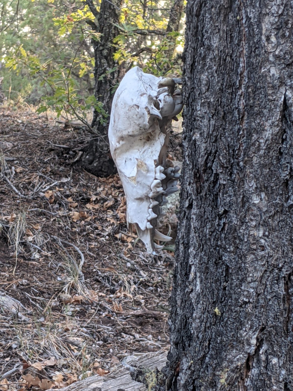
Very carefully. It was much further down than it had been up, and frequently quite steep. My knees let me know they were there. And so did the bleached skull of some small predator (fox? coyote?) that someone had hung from a tree.
But 45 minutes later, I was at the base and working my way across the flats on a twisted, rutted dirt road. I went as far as where the trail left the road. Someone had made a nice, wide flat campsite there, and it was time for sunset. I finished making camp by twilight. There would be no night hiking for me in this condition. I just needed sleep.
Trail miles: 20.5
40.7 miles to Highway 60 and Pie Town!


The skull of a predator judging by the canines, but what species? 


4 replies on “Day 24: Linking back up”
1. What does Supravigintal mean? Tried to look it up but no luck
2. I think it is a wolf skull
3. Your mental strength when exhausted is admirable. You are tough!
The only place you’ll find the word supravigintal on the internet if you Google it is on my AT blog because it is a term I coined. But its meaning should be apparent from the Latin roots. https://www.online-latin-dictionary.com/latin-english-dictionary.php?lemma=VIGINTI100
Where is Gina Luck when you need her? 🤣
My question too. Made a note to look up the same word.