Slow going again on this section. Not necessarily as draining, but definitely less interesting. And, for the most part, just as hard to get a good pace going.
As expected, I slept in a bit, which is to say, I stayed in my tent doing some maintenance and self-care tasks, as well as finishing a blog post it was too late to finish the night before. I didn’t leave camp until 7:30.
The first part was a breeze. Up to the shoulder of the mountain and down the ridge on what amounted to an actual footpath, if a bit overgrown. At the bottom, the trail soon joined a brand new perfectly cleared and compacted section through a bit of forest. After a mile, the forest continued on about the same while the trail switched to a more overgrown and easier to lose state. I took my morning break behind a nice rock formation.
As far as elevation goes, it was pretty gentle rollers all morning. Climb over a ridge, come down the other side, etc. The trail came down to an open area with a fence across it. Where there once would have been a gate someone had replaced it with a section of wired in barbed wire fence. And if that wasn’t rude enough, the bottom wire of the whole fence was not barbed except in that section, where they knew hikers would be having to crawl under it. I bent the separator wires to give as much crawlspace as possible for me and the next person, but I would have liked to have just removed the wire altogether so whoever was responsible would learn that that sort of thing was unacceptable. Put the gate back!
Just after a road crossing, I had a gut feeling it was time to stop. I had lunch there and by the time I left a bit over an hour later, some heavy clouds were rolling in. They would, throughout the rest of the day, go from partly cloudy to completely overcast. At this particular moment, they intermittently gave me long periods of shade.
Just a bit after lunch, I went through a tension gate and crossed the floodplain of East La Jolla Canyon. There was a sign saying the area ahead was full of obstacles due to a fire. It wasn’t lying.
On the first ridge, I kept losing the trail. In places it was marked only with yellow ribbons, possibly because I was on a future reroute. Other times, I was following cow tracks around the side of the ridge when the trail was way above me. But with all the downed trees, the cows seemed to have the better sense of it. Eventually, I climbed up to a nice section of brand new trail, clean and clear of the ankle breaker rocks. It lasted all of ten minutes, dead ending into a series of fallen plastic and wire flags showing where it would continue. Straight up another hill, that’s where. I crawled under a tree near the top and had a second lunch as my afternoon snack.
I came up to the shoulder of Pinon Knob and the descent there was through a light jungle gym of fallen trees, some with CDT markers still attached. It was not as long or as dense as the Mt. Hood fiasco, thank goodness. At the bottom of that began the day’s first serious climb. It was just like the day before, 45 degrees straight up, grass and chunks of rock, occasional markers and cairns. But this time the challenge was increased by the way being constantly blocked by fallen trees. Up 500 feet I went in a half a mile.
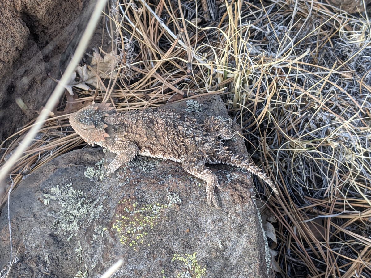
My first animal encounter highlight of the day happened on this climb. An enormous Horned Toad Lizard, much bigger than I am used to seeing, got scared off my path. I ran it around a bit to get a good look at it.
The burned forest continued. No footpath in sight, but even if there were it would have been crossed by fallen trees. This section was a nightmare to navigate by sight. For the most part, though, it was predictable. It tried to stay on top of the ridge the whole way.
And there were markers enough. Three kinds: cairns, tree cuts, and plastic CDT logos. The next marker visible from the last could be any of the three, and usually only one marker could be seen if any at all. If it was a cairn, it was probably too short to be seen over a rise or a snag until I came closer. And there were plenty of natural rock formations that resembled cairns from a distance. If it was the CDT logo, it might be so melted in the fire that it has shrunk down to near invisibility. If it was a tree cut, the cut and the surrounding bark might both be burnt black, but it was probably cut in a tree where the underlying wood was the same color as the bark anyway. Either way, I had to scan both the ground and the trees for the next marker each time, something easy to forget to do.
And there was a good heuristic for spotting the next marker: look straight up the hill, straight down the hill, or toward the center of the ridgeline. Head in that direction until you see one. I got so used to this tactic working that I lost the trail doing it.
I came upon a bull in the trail and had to bully him and evict him from my path several times in a row to keep going. Then I looked at my GPS and saw that I was walking down the wrong ridge and had been keeping him running for no reason. Sorry!
Back to the trail and over the next ridge, I found a good log to sit on for dinner. It wasn’t under a tree like usual because the cloud cover was so final that everywhere was shady. It took an hour or so to cook and eat and so a number of other chores, even though I hadn’t even been hungry yet. But I knew that I could hike faster if I ate something substantial.
And I did. The trail did not change by much. Somewhat fewer fallen trees. But I did hike faster up the hills and over the rolly rocks. I kept going past sunset until it was just about too dim to be able to make out the next marker and stopped in a saddle. The first piece of ground I came to was perfect, but was right next to a tree leaning on some other trees and groaning loudly whenever the wind blew. I moved just far enough away that that wouldn’t be so loud to keep me up all night and made camp. Asleep shortly after ten.
Trail miles: 18


The only way through is under 


This bright yellow lichen caught my eye 


It’s like the trees died trying to bend themselves into a round hut of some sort.
https://youtube.com/shorts/yreb4hYEC0g?feature=share