My last few days of hiking in California were almost completely solitary. And my trip north had me dealing exclusively with people and situations completely unrelated to hiking. But now I was setting off down a very popular stretch of trail in a time when hiking is more popular than usual: the week leading up to Labor Day. I sure wouldn’t be getting the trail to myself. But with my legs rested, my pack feeling light, and the trail pretty worn and gentle, there was a good chance I would be outpacing any short sectioners I came upon.
Note that in this section, I had to walk north to the border and then south from there. Because the Canadians have closed the border to all Americans, this backtracking is mandatory. Otherwise, I would have crossed into Canada and hitchhiked or bussed or whatever to Manning Park to go south the easy way. But since it is required for everyone this year, I get to say that the trail is 30 miles longer than usual. And to that end, I’m counting both the northbound and southbound miles north of Hart’s Pass as trail progress.
Day 1
I woke just ahead of the sun and started packing up. Wayne opened the side door to offer me some hot water for coffee. I had him pour some in my breakfast smoothie, thinking it would be pleasant to drink it slightly warm with the cold wind still whipping through the campground. It turns out it just doesn’t taste right warm, but I had to drink it anyway. It was my first meal in around 18 hours after all.
I set out across the campground trying to find the easiest way to the trail. It turned out to be walking the road up to the Brown Bear Trailhead. I would be starting 2 miles south of Hart’s Pass, but for the day I had planned, I could afford the extra miles.
As I crossed the hillside above the campground, I could see that Wayne had already driven away, presumably moving to park at the trailhead to pick up the PCTers he came to meet. We’ll talk about them shortly.
I walked through Hart’s Pass without really looking around because I was dead set on reaching the next water source just 0.4 miles ahead. I hadn’t filled up from the creek in the campground because I was eager to get started and not thirsty, and I had started out in my pants because it was windy and cold all morning. I was looking forward to changing into my shorts while my water filtered more than I was looking forward to having water.
It was a bit less appealing when I realized the stream was right below the road where a van was parked and I was going to be changing potentially right in view of someone up there. I changed quickly just in case.
A mile or so later, I had to stop at a trail register and make myself a backpack tag. The trail system north of Hart’s Pass requires a self-issue permit, but I don’t remember seeing anyone there checking them.
The next few miles was basically level trail, which meant I was practically running, passing people as expected, sometimes multiple times as they would pass me while I stopped for breaks or lunch. The trail ran along the sides of ridges and through a lot of passes, so the views were constant and impressive, except that I was quickly inured to their beauty through overexposure.
As I was wrapping up lunch, sitting next to a small stream, who should come walking up at a suspiciously slow pace but Gorilla. He was walking with another man I didn’t recognize. You’ll recall my first encounter with Gorilla from my first dispatch from the trail. He was literally running down a hill and climbed up the next hill at a pace to swift to catch.
I have to be honest–I was 100% expecting to see him that day, albeit much earlier. He was one of the people a Wayne had come up to the pass to meet and drive to Sea-Tac. The other came up behind him shortly: a tiny Argentine girl named Kayotea. Wayne had already told me all about her, the documentary she was making, and the lengths she had gone to to make sure he arrived at the right place at the right time since he had no way to contact her on the trail. She, on the other hand, had never heard of me. Gorilla introduced me in fluent Spanish. I told them that Wayne was already waiting on them and had been all morning, and they, lamenting their tardiness, rushed off to meet him.
I ended the day at a beautiful campsite just shy of Rock Pass with a nice spring. I was just over 15 miles from the border, which meant I was perfectly placed to tag out the next day. There were three other people at the same campsite, but I only said a few words to each of them that day. Don’t worry; I’m not mentioning them for no reason. They will all be mentioned again.
Total distance: 18 miles


Day 2
Got up as soon as I woke up and filtered water from the spring while I was packing. I was not the last one out of camp, but the two old men made it out just before me.
The climb up Rock Pass was no problem, but the ascent of Woody Pass less than two miles later was brutal. For some reason, the trail dives down 600 feet, then rises 700 feet again just in the space of 2.6 miles between these two passes. I had to take several breaks on the way up the steep climb.
Nevertheless, I completed the 7 miles to the overlook by noon. I climbed up on top of the ridge, ate lunch, and set up my tent. It was an amazing view and a very windy spot. Very rocky too. Hard to get all the stakes in. All of them had to be weighed down with heavy rocks just to be sure they would resist the wind.
I left all my camping gear and most of my food there with the tent, intending to slackpack the 8 miles to the border and back carrying only snacks, water, water filter, Garmin, and toilet paper just in case. For some reason, I forgot to take my stove out of my pack, but I didn’t even notice. My pack was so much lighter, I felt like a gazelle. After a few pictures of the view, I took off down the hole at a run.
The trail started out as easy and viewful as it had been, but 4 miles from the border it was consumed by thick brush and eventually heavy forest. A bit gross to push through, but I forced myself to keep the pace.
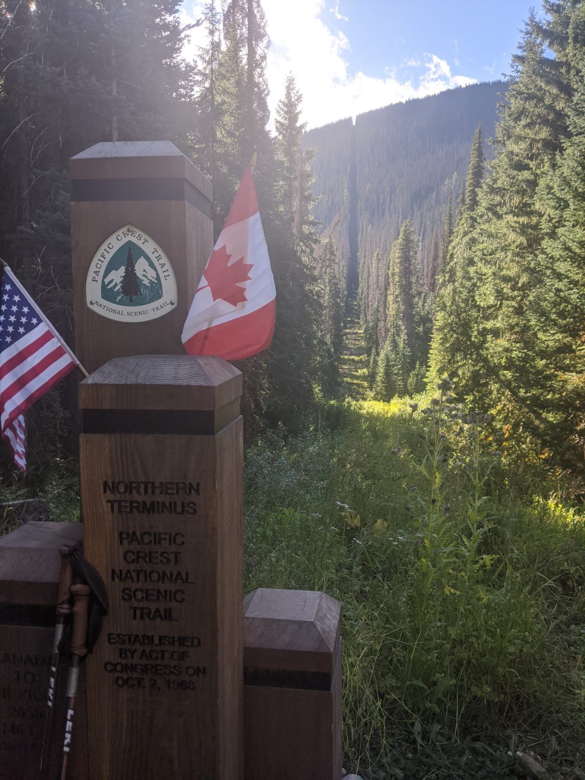
I reached the tree cut and monument that mark the border and the northern end of the PCT a bit after 4pm. I was the only one there. The flies there were horrendous. I took a few pictures and a video of myself climbing the monument. Then I had a drink and a snack and began the hike out, running from the flies.
It was all uphill on the way back, but I was light enough I could keep roughly the same pace I kept coming in.
Just a mile or so up the trail, I properly chatted with Snow White, a Green Bay fan from Green Bay who was on the same flip-flop plan as me, though I think she flipped from further south. She had been in the same campsite as me the previous night, and had still been in bed when I hiked out. Nonetheless, here she was, just 2 miles behind me. She was carrying her full pack and told me she planned to go a quarter mile over the border to camp at the nicely outfitted campsite in Manning Park. Obviously, if she were caught there, she would be in massive trouble with Canadian border police, but she was willing to risk it. I admire her moxie. I wished her luck, and picked up my pace again.
The sun set as I was beginning the climb back up from Lake Hopkins to the viewpoint, and I got some great pictures of the fading colors behind the distant mountain range.
I arrived at my camp just before 9pm. The colors of sunset had not yet completely faded in the west and the moon was rising in the east. I pulled on a coat and dove into my tent as soon as I could to hide from the driving winds on across the ridge. I cooked dinner in the vestibule while tucked comfortably in my sleeping bag. I had to put my bear can in the windward vestibule with my shoes on top of it to keep the wind from pushing the flap and tent side into my face while I slept. I slept cozily and well despite the constant rattling of the tent fabric in the wind and the light of the moon in my eyes. Doing that many miles in that short amount of time buys enough weariness to sleep through anything.
Total distance: 23 miles


Day 3
The only event worth mentioning from this day is the man with a line of friendly well-behaved mountain goats carrying his stuff. I passed them as I rushed down from Woody Pass trying to find a place out of view of humans in one of the most exposed parts of the trail. The goats all looked at me and stepped deftly aside as I passed at speed. I complimented the man on how polite they were.
“Yeah. Sometimes,” said he.
The same bit of trail that I breezed over so easily just two days prior felt like a lot more of a slog in the other direction. Maybe it was just that I had seen it already and was eager to be done with it.
I stopped just before sunset just 4 miles north of Hart’s Pass, thankful that 8 would get to cover some new ground the next day.
Total distance: 19 miles


Day 4
My goal this day was to get more than halfway to Rainy Pass so that I could get into Mazama the next day while everything was open. I may not have awoken with the sun, but I definitely packed as quickly as I could and hiked out at speed.
An hour and a half later, I was back at Hart’s Pass. Since I had already done the two miles between there and Brown Bear Trailhead, I started walking down the road into Meadows Campground. I chatted with some hikers beginning their trip to the border. Within a half mile, though, I managed to flag down a truck to give me a lift to the campground. The old man (who frequently hunted deer in the area) said he was actually heading up to the trailhead himself, so he drove me all the way up there. He wanted to check that his son’s truck was there, as his son and friends were beginning a southward hike that morning. He pointed the trick out to me. I got out and started making lunch and he left.
Now, the reason that I had originally planned to get dropped in the campground was to collect water from the creek that flowed through it. I was absolutely out of water and the next ten miles offered no opportunities to collect. It seemed like I would have to hike back down a half mile to get the water and then back up again, not only wasting the extra ride I’d gotten but completely negating its savings.
Then my Yogi Bear instincts pricked up. I looked in the bed of the truck the old man had pointed out. A half full case of Dasani bottles and several more empties scattered about. These kids had been so trusting that they had left one of those fancy Yeti-style coolers just sitting up there for all to see. Or they had left in a huge hurry without thinking. Or they were filthy rich and didn’t care if it was stolen. No matter what it was, it was apparent from the old man that these were the type that would have gladly donated some water if I had asked. And since I knew their names and descriptions, I could surely get post hoc permission if I saw them. I put 32 oz in my water bag without taking a single extra step.
Crossing the exposed ridge leading to the long switchbacking dive into the Methow River canyon, I passed a northbound PCTer asking about possible nearby water sources. I mentioned the creek running through the campground. I may or may not have described it thusly:
In about four miles, you’ll come to a trailhead where you can go a little off trail to get water two miles earlier than Guthook says, but just to make sure you know which trailhead I’m talking about, listen closely as I describe it. It’s the one where you will find a big, black Ford truck belonging to the three guys wearing camo you surely passed earlier as they left on a hike that will take them at least three days. You’ll know it’s the right truck by the half full case of Dasani water in the bed and the empty bottles scattered about as if by a group who did not carefully count how many bottles they were using and would not notice if there were a few extra empties than when they left. If you see that truck, you’ll know you’re at the right trailhead, alright?
The switchbacks were a total pain, all down an exposed rocky hillside. The rocks were rough enough to snap the tip off one of my trekking poles. I took at least one lie down and drink a lot break just to rest my feet. But once I came through Glacier Pass and started following Brush Creek down into the canyon, the overgrowth swallowing the trail was even more annoying.
I stopped at a clearing just over the Brush Creek crossing to have a snack and fill up on water again. I was passed by the large group I had just passed a mile back that was planning to camp nearby. They had a wonderful dog who loved to try to pull huge rocks out of the river in hopes of instigating a game of fetch. One of them also explained salmonberries to me. I gave one a taste, and believe it or not, it actually tasted like salmon. I also found a few sweet, ripe raspberries here, the last of the season.
I hiked on again into the dense overgrown undergrowth, tripping on every other rock in the trail since I couldn’t see my feet. Although I had originally intended to go a bit farther and there was plenty of light left in the afternoon, I was so enamored of area around the Methow River bridge that I decided to stop after less than three more miles. I put my tent right there next to the bridge where the flowing water would lull me to sleep, used some fancy ropework to hold the broken pole in place without the tip to secure it in its grommet, cooked sitting on a bench built next to the bridge, and went straight to bed. A couple more hikers set up in a nearby site after dark, but I only heard them. I wouldn’t see them until the morning…
Total distance: 17 miles


Day 5
It’s the Saturday of Labor Day weekend. Clearly, I’m not going to have the trail to myself. Might as well face that tune immediately by chatting with my neighbors.
Fortunately, they were a couple of thru-hikers very close to finishing their trip. I think one of them was Amsterdam? I shared what I knew about the difficulty of the trail ahead and the quality of the campsites I had seen. They told me I had nothing at all difficult ahead of me. Rocks, but not the kind that slow you down. They were right.
Just a mile into my hike, as I was about to start the climb to Methow Pass, I was busted hard by another horsefly. This time my knees literally buckled under me, and I face-planted into the dirt. Luckily, I hadn’t made it to the rocks yet. Somehow, I always get stung deep in wooded valleys like that, so I guess it could be worse. Also, if it had happened just five minutes later, it would have been witnessed by two hikers I met coming down the hill.
The climb was short and easy for such a pleasant morning, but as soon as I came over the pass and saw the view, I was filled with exuberance and kicked into high gear. The trail was cut into the side of an exposed red dirt and rock hill and had hardly any elevation change (slightly downhill if anything) for the next three miles. Which meant I literally ran for the next three miles. I was blowing past hordes of day hikers at a speed that barely gave them time to step aside. I certainly wasn’t going to put on a face mask for every person I passed–there wasn’t time for it.
There was one big climb at the end of that joyrun section, and the number of day hikers only increased as I got closer to the road. There was a particularly large crowd, dozens of groups, near Cutthroat Pass, but I managed to find a spot with a view just off trail to sit alone with my lunch.
From there, it was all downhill to Rainy Pass, so I started running again. Except that I stopped every time there was a beautiful waterfall or gushing creek flowing over the trail. I was so eager to reach the road, those last five miles felt like they went on forever. A common feeling on town day.
Despite the thousands of hikers with cars at the pass, I had a strangely difficult time finding a ride to Mazama. The people I chatted up were all going the wrong direction. People at the highway itself weren’t stopping. I talked to one guy who looked like a real distance hiker and learned that he had just finished making his own 30L ultralight pack on his home sewing machine for a hundred bucks in materials. But he was starting a hike, not leaving.
Finally, a father-daughter pair I read spoken to who were heading the wrong direction decided to go out of their way to give me a lift to Mazama. Thanks Kevin and Emily!
They dropped me in the middle of town right next to the outfitter and went back east.
The outfitter managed to find a suitable replacement for my trekking poles. Great. I went next door to the store and cafe. I got my supply of limes and went to sit on a rock with a salty baguette and a root beer at the garden entrance to wait for a table to open up. It was a madhouse in this tiny town on Labor Day Weekend, so it took a good hour of waiting. I celebrated with some baked goods and a proper beer.
Eventually, I had to get a move on over to the ranch where I had stashed my food. I found some folks outside the Chicken Coop who fetched me my bag of food and then plied me with leftovers of the food they were eating. Turns out they were not the operators of the ranch, but a dirtbike training business and its customers. I chatted with all of them for most of an hour while I transferred all the food to its proper places in my pack. Before I could leave, I had to take a picture with some branded booty shorts attached to my pack for their Instagram. They insisted I take the shorts with me.
I had yet to find any place where I could get a shower and laundry, and the only sure bets were in a wholly other town even further east. There was an option for lodging in town though: Ravensong’s Roost. It was normally a hiker hostel in other years, but this year it was being rented. Hikers like me were still allowed to camp beside it though. So I walked over. It was a fifteen minute walk out of town.
I found a traditional tipi built behind the house and a bathtub that could be the solution to my bathing and laundry issues. I put my pack in the tipi along with the fancy chocolate I’d just bought and the remnants of the baguette I hadn’t been able to finish.
Soon, one of the residents arrived by bicycle, so I made sure it was okay to stay in the tipi. It was. She also offered to let me wash clothes and shower inside in the morning, assuming her roommate agreed. Wow! Things were going to work out okay. I climbed back into the tipi, rolled out my sleeping mat, and snacked on chocolate while watching shows online. Oh yeah, the other feature of Ravensong’s Roost is its location directly adjacent to a Verizon cell tower. You can thank that tower for whichever blog post I posted the day before Labor Day.
Total distance: 15 miles


One reply on “Tagging the border: Hart’s Pass to Rainy Pass”
These are some gorgeous shots! So happy to see the video of the Northern Terminus. When I see the sign, Welcome to Canada, is it in the USA side or the Canadian side?